Before & After Photos
Summary
About the Project
The 30th Street Corridor is critical for Colorado Springs. It is a highly-traveled tourist, residential route, but also used by trucks and commuters. This is the gateway to one of the most visited attractions in the Pikes Peak region, Garden of the Gods Park. It is also a connection for businesses located along 30th Street, Colorado Avenue, and Garden of the Gods Road.
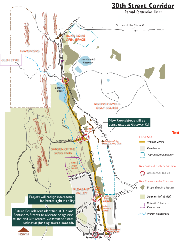
The City has identified the need for several roadway and safety improvements along 3 miles of 30th Street between Fontanero Street and Garden of the Gods Road. Transportation-related deficiencies within the corridor include a lack of roadway shoulders and drainage facilities; aging street pavement with adjacent hillside erosion and slope destabilization; and a lack of multi-use roadway facilities. There are also safety and mobility deficiencies at corridor intersections, and inadequate access for emergency vehicles and evacuation. The corridor is one of five designated wildfire evacuation routes for northwest Colorado Springs.
The construction project includes:
- Widened shoulders on 30th Street
- Intersection improvements at Fontanero Road, Water Street and Gateway Road
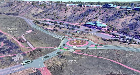
- New roundabout at Gateway Road
- New storm sewer system
- New water quality pond
- Retaining walls
The primary goal is to increase safety through the corridor. This will be achieved by widening the roadway with asphalt multi-purpose shoulders and improving the intersections of Fontanero Road, Water Street, and Gateway Road. Gateway Road will be reconstructed with a single-lane roundabout that includes a pedestrian underpass, connecting to the Foothills Trail inside Garden of the Gods Park.
The widened shoulder will serve many purposes. It will create space for emergency vehicles to safely pass other vehicles, space for occasional vehicle breakdowns, and allow more room for frequent bicycle commuters. The project will also install new storm sewer, a water quality pond, curb and gutter, new asphalt, and retaining walls.
30th Street has also been identified as an Emergency Evacuation Corridor for Colorado Springs. The current roadway width is 24-feet wide, with no shoulders. Widening the road will allow drivers to pull over more easily in the event of a minor roadside emergency. Adding asphalt shoulders will also allow emergency vehicles, like ambulances and fire trucks, to pass other vehicles more safely.
The project improvements encompass two miles of work and will construct necessary improvements along the corridor, including drainage abatement and slope stability.
Project Benefits
- Creation of an effective emergency evacuation corridor for northwest Colorado Springs
- Improve safety and mobility for all travelers, including motorists, bicyclists, and pedestrians
- Stormwater improvements, including improved stormwater quality runoff
- Stabilized hillside slopes
- Creation of a “sense of arrival” for the Park entrance
- New pedestrian underpass for the Foothills Trail at Gateway Road
Funding
- Design funded by City Public Works capital funds
- Construction funded primarily from Federal Surface Transportation Block Grant Program
Design Elements
The City worked with consulting firm Felsburg Holt and Ullevig to design improvements for 30th Street from Fontanero Street to Mesa Road.
Federal funding is being used, so the design required approval through the National Environmental Policy Act (NEPA) process. The City has performed all NEPA requirements and construction started in the fall of 2021.
Design Element Considerations
- Public involvement: The city has performed property owner interviews, three stakeholder meetings, and one public meeting. There will be another public meeting in the fall of 2021 with the contractor.
- Survey, digital terrain modeling
- Title work and property oversight: needed easements were secured for the project.
- Geotechnical investigation and design: identified preliminary constructability issues/requirements for the project; retaining wall and side slope design; subsurface investigations; laboratory testing
- Pavement design: field investigation of existing pavement; drilling and sampling; sample testing; preparation of a pavement report
- Structures: soldier pile walls; gravity walls; pedestrian underpass at Gateway Road
- Drainage engineering: new storm sewer and water quality pond
- Traffic safety: traffic data collection; traffic analysis; signal warrants
- Landscape architecture: streetscape and landscape concepts; future art; aesthetics; lighting
- Environmental analysis/NEPA requirements: air quality survey; geologic soil survey; water quality analysis; floodplain analysis; wetlands field evaluation; biological resource survey; historic properties collection and evaluation; archeology/paleontology and Native American consultation; land use mapping; social and economic resources mapping; environmental justice analysis; utility survey; Section 4(f) and Section 6(f) inventory, mapping, analysis; technical noise assessment; visual resource assessment; energy requirements and conservation; and a hazardous materials survey.
FAQs
 What will 30th Street look like after this project is complete?

This project will increase the width of the road from 24 to 37 feet. The new design will allow for two 11-foot travel lanes, a 5-foot multi-use shoulder on each side, and a 2.5-feet of curb and gutter on each side. The proposed cross section was developed due to existing topography on the east (steep slopes with slope instability) and to reduce impact to existing neighborhoods on the west side of the corridor.
Will the project add bike lanes or sidewalks?
No, the multi-use shoulders may be used by bicyclists and for vehicular emergency pull off, but the added shoulder will NOT be striped as a designated bike lane. Existing topography (steep slopes with slope instability) will increase the cost of a typical sidewalk installation. Our current budget will not allow for construction of sidewalks at this time.
What is the recommendation for the Gateway Road intersection?
A roundabout intersection was identified as the recommended alternative. A roundabout will most effectively meet the community values related to the park and keep a rural, unobstructed setting. A roundabout addresses all of the issues identified at this intersection – speeding traffic, congestion at Gateway Road, and the desire for a gateway feature.
- Federal Highway Administration roundabout information
- Insurance Institute for Highway Safety roundabout information
Why was Mesa Road intersection geometry changed?
The intersection geometry at Mesa Road was identified as a safety issue, and modified prior to the 2C Roadway Improvements that will occur on 30th Street, north of Mesa Road (2019). City Traffic Engineering reconfigured the entry angle to be more perpendicular for better driver navigation. This new geometry also removes the acceleration lane, to reduce accidents and provide a safer turning movement.
Was a traffic study conducted?
Yes, a traffic study was conducted in June 2017 to capture peak traffic data at four intersections between Fontanero Street and Mesa Road. Crash data was compiled for total crashes, type of crash, locations, and cause of accident.
What is the project schedule?
Construction started in the fall of 2021. Construction is expected to last approximately 18-24 months.
Exhibits
Jan. 18, 2022, Construction Drone Progress Photos
30th Street Corridor Project - flyover Jan. 18, 2022 from MRG Ltd on Vimeo.
30th Street Corridor Project - Jan. 18, 2022, Construction Drone Progress Photos from MRG Ltd on Vimeo.
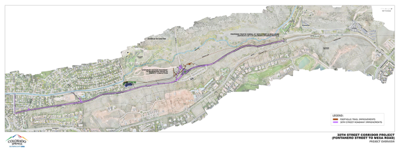
Project Overview 2021-2023

Roundabout traffic modeling (2018 Preliminary Design):
Public Information
Newsletters
Past Public Meetings
- June 2, 2022 – Construction Update – Virtual Presentation
- February 4, 2022 - Coffee with the Contractor
- October 11, 2021
- Thursday, June 14, 2018
- Wednesday, October 9, 2019


