South Suburban Reservoir in Stratton Open Space to be closed to public access
Due to increasing water quality concerns and other considerations, Colorado Springs Utilities will no longer open South Suburban Reservoir for public access beginning in 2026. The reservoir, which has been closed for necessary repairs since April 2024, stores raw (untreated) drinking water for Springs Utilities customers. For periods over the last two decades, it has been opened to the public during warmer months, eventually becoming an unofficial destination for off-leash dog recreation. Read more about the factors influencing the closure decision at https://www.csu.org/blog/south-suburban-reservoir-public-access
South Suburban Reservoir, located in Stratton Open Space will remain closed for the 2025 season due to repair work being performed by Colorado Springs Utilities.
Stratton Open Space will remain open throughout the project; however, there may be intermittent closures on Ridgeway Trail. Trail users must exercise caution while navigating the area, follow all posted signage, and adhere to park rules, including keeping dogs leashed. Alternate trail options will be available when Ridgeway Trail is closed, and users should plan their routes accordingly.
Please note, there will also be construction vehicles travelling on N. Cheyenne Canyon Road while repairs are underway.
For more information, visit South Suburban Reservoir closure.
Information
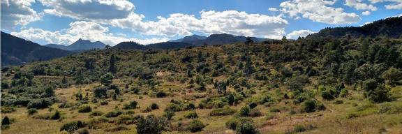
Stratton Open Space offers 318 acres of open space, trails, and wildlife habitat for Colorado Springs. Next, to North Cheyenne Canon, the Stratton Open Space offers five distinct ecosystems, miles of trails, a rich variety of wildlife, and access to the Pike National Forest.
The Stratton Open Space is located adjacent to North Cheyenne Canon Park. Take 21st Street South (this street turns into Cresta Road) and go right on LaVeta Way to the trailhead parking lot. There is also a trailhead on Ridgeway Avenue. The trailhead to the Chamberlain Trail is past Starsmore Discovery Center on the right.
Park Hours:
5 a.m. – 9 p.m. (November – March)
5 a.m. – 10 p.m. (April – October)
Gates are locked each evening upon park closure
Follow the Leave No Trace Seven Principles
The City of Colorado Springs Parks, Recreation & Cultural Services department is proudly partnered with the Leave No Trace Center for Outdoor Ethics in order to promote environmental stewardship and safeguard the natural, cultural, and historical resources that make Colorado Springs such a fantastic place to live and visit. Follow the Leave No Trace Seven Principles to help keep our parks, trails, and open spaces healthy and sustainable. Learn more at lnt.org
|
| Plan ahead and prepare. A little preparation goes a long way! Checking the forecast, planning your route, and reviewing the Rules and Regulations will help prepare you for your Stratton Open Space adventure. |
|
| Travel on durable surfaces. Stay on designated trails to minimize soil erosion and preserve the Open Space’s natural features. Muddy trails? Hike right through them to prevent trail widening. Please respect all undesignated trail closures. |
|
| Dispose of waste properly. Please pack out all trash items, including bagged dog waste, or place it into trash cans before leaving the park. |
|
| Leave what you find. From wildflowers to interesting insects, Stratton Open Space is full of fascinating features! Remember to take pictures of these fun finds and leave them where they are for other park users to discover. |
|
| Be careful with fire. Sparks and grassy meadows don’t mix. Fires, grilling, and smoking are prohibited at Stratton Open Space. Do your part and help us protect this area from wildfires |
|
| Respect wildlife. Stratton Open Space provides essential habitat for a variety of animals. Please observe all wildlife from safe distances and never feed them. Always keep your pet on a leash for everyone’s safety. |
|
| Be considerate of others. Enhance the experience of other Stratton Open Space visitors by sharing the trail. Cyclists should always ride in control and alert others if approaching from behind. Be mindful of “Hiker Only” and “Bike-Only” trails. |
© 1999 by the Leave No Trace Center for Outdoor Ethics: www.LNT.org.
The preservation of the Stratton Open Space was made possible through partnership and widespread community support:
- Cheyenne Commons
- Citizens of Colorado Springs
- City of Colorado Springs TOPS Program
- Colorado Springs Utilities
- El Pomar Foundation
- Gates Foundation
- Great Outdoors Colorado
- Palmer Foundation
- Trails and Open Space Coalition
Fire Mitigation Work

In 2024, the Colorado Springs Fire Department (CSFD) Wildfire Mitigation Section in collaboration with Colorado Springs Parks, Recreation and Cultural Services and City Forestry, completed fire mitigation on 266.7 acres in Stratton Open Space to reduce wildfire risk.
Native seeds and woody materials have been applied to the soil to help restore and revegetate the open space.
- Over 215 acres have been completed including Units 1 through 4 and 6 through 8.
- As of Jan. 16, the contractor is working in unit 5 and plans to move into until 10-12 soon.
- Unit 9 will follow
Goals of mitigation efforts
- Reduce the wildfire risk to surrounding neighborhoods and public property
- Protect critical infrastructure by reducing wildfire risk to adjacent access roads and utilities
- Prevention of post-storm slope erosion by reducing the risk of catastrophic canopy loss
- Reducing wildfire risk to wildlife habitat, recreation resources, biological areas, and natural and cultural resources (i.e. trails, scenic vistas, riparian, historical, archeological)
Objectives
- Reduction of woody biomass by at least 50% across the project area
- Reduce ladder fuels across all stands.
- Create defensible space adjacent to and in conjunction with residential property while providing for aesthetics.
- Maintain the natural character of lands in relationship to the surrounding area, recreational opportunities, and natural and cultural resource management.
Public Meetings
A public meeting was held on Wednesday June 26th from 6:30-7:30pm to share the project details, review the scope of work and timeline as well as answers attendees’ questions. A copy of the presentation and the fire mitigation treatment map are provided below
Frequently asked questions
Is there snag or habitat tree retention?
The contract is leaving high quality habitat and snags for nesting, roosting, cover, etc.
How is treatment going to be completed in the spring creek drainage
No machinery will be used in the incised drainage. Only handwork and winching of materials will occur to minimize impact and negative resource damage.
Is there a buffer off of trails?
There is a 10-foot buffer of minimal cutting along trails to preserve trail corridors. If trails are damage, they must be brought up to current standard or better. Monitoring of trails will be active throughout the administration of the contract.
How will public outreach continue throughout the project?
The project will be collaboratively publicized via City and CSFD PIOs, the project website, and subject matter experts such as Wildfire Mitigation Section, Parks, and Forestry employees.
What can users expect to see in the Open Space?
Users can expect to see skid steers with masticating or chewing heads for vegetation. Chainsaws and brush-saws will also accompany the machinery work. Minimal to moderate noise disturbance may be present at certain times. An “open-look” after work has been completed will be expected. Minimal soil disturbance is expected; however, these sites recover quickly with grasses, forbs, and sub-shrubs.
How will trail closures be addressed?
Trail closures will be collaboratively publicized via City and CSFD PIOs through the project website and on Parks, Recreation and Cultural Services social media, when possible. Trailheads and trail junctures will have updated signage to warn park users and suggest detours if possible. Forestry work signs, flagging, and safety cones may be used to reinforce closures. Trail closures must be obeyed by all users. Removal of closure infrastructure and public information on the project is a violation of the Fire Code. As mitigation work is dynamic, there can and will be rolling closures throughout the park with varying timelines.
What is actually being cut or removed from the project?
The project is focusing on removal of 50% of Gambel oak and “shrub-like” species. The removal is focused on smaller diameter, dead, dying, and diseased stems. Leave or uncut groups and clumps are meant to be left as part of the 50% retention. Small conifer or evergreen trees up to 5” in diameter are also slated for removal.
Management Plan
The Stratton Open Space Management Plan was adopted by the Park and Recreation Advisory Board on March 10, 2016. We thank the public for their valued input and participation in the public process.
View the approved Stratton Open Space Management Plan
Trails
Stratton Open Space Trails
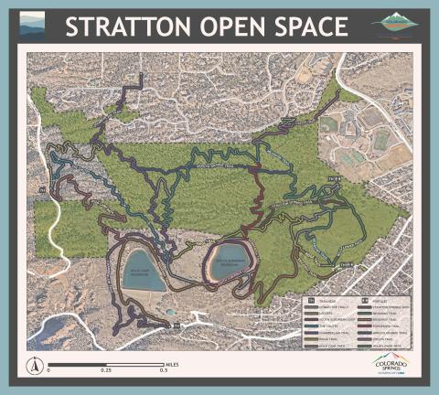
Current Trail Lengths: Chamberlain-Ridgeway Spur: 1.1 miles; Gold Camp Path: .8 miles; Ponderosa: .4 miles; South Suburban Lower Loop: .4 miles; South Suburban Upper Loop: .6 miles; Stratton Springs Path: .5 mile; Upper Meadows Loop: .7 miles; Wildflower Path: .7 miles.
General Description: There are three trailheads that service the Stratton Open Space: 1) La Veta Way off Cresta Rd; 2) Ridgeway off W. Cheyenne Blvd. and 3) trailhead on the north side of the road about .3 miles up the road from the main park gate by the Starsmore Discovery Center. Most of the trails within the Stratton Open Space are easy to moderate in difficulty and offer "loops" that allow users to enjoy the Open Space. Keep in mind that all trails designated as "paths" are for hiking only; equestrians and cyclists may use all of the other loops.
Friends of Stratton Open Space
Friends of Stratton Open Space is an all-volunteer 501(c)(3) nonprofit organization. The Friends work with the city park ranger to support and improve Stratton Open Space.
Friends of Stratton started in 1996 as Cheyenne Commons Alliance, to preserve the open space when it was threatened with development. Cheyenne Commons advocated for preservation and helped raise the funds needed to purchase the open space, raising about $500,000 of the $5.9 million needed from more than 700 individual donors. After the successful acquisition, Cheyenne Commons Alliance (still the legal name) transitioned to supporting the open space. The Friends provided funds for additional services and amenities and also worked with the Parks staff on volunteer projects to help maintain and improve Stratton Open Space. Over the years, the Friends have also offered informative presentations. These days, the focus is on volunteer projects to improve the trails and natural resources of the open space.
Connect with the Friends of Stratton Open Space through their website and Facebook page.

By receiving this highest standard of recognition, Gold Standard Sites are exemplary models, encouraging other public lands to ensure that Leave No Trace education is part of everyone’s experience when spending time outdoors. Learn more about what it means to be a Gold Standard Site here.

